Reserved for public purposes
Congress of the Republic required 400 acres in the Government Tract to be reserved.
The land beneath the plan
Sand Beach Reserve — public land on the north shore of Lady Bird Lake, set aside by the Republic of Texas in 1840 for public purposes. Mostly parkland, it's now threatened by plans for three luxury condo towers where the TownLake Y sits. Here is the interesting history, the plan from the YMCA and developer Millennium Partners, and what you can do about it.
Start with the record
This site separates original records, attributed analysis, and present-day advocacy. Begin with the map, follow the chronology, or inspect the source documents yourself.
See how the 1848 patent, the historic bluff line, and three surveyed boundaries overlap.
02Trace the Reserve from the Republic of Texas through the 2026 formal development filing.
03Open the deed, map, history, and source material already available in the archive.
The central question
Did part of the five-acre tract return to the State of Texas in 1963?
Attributed analysis
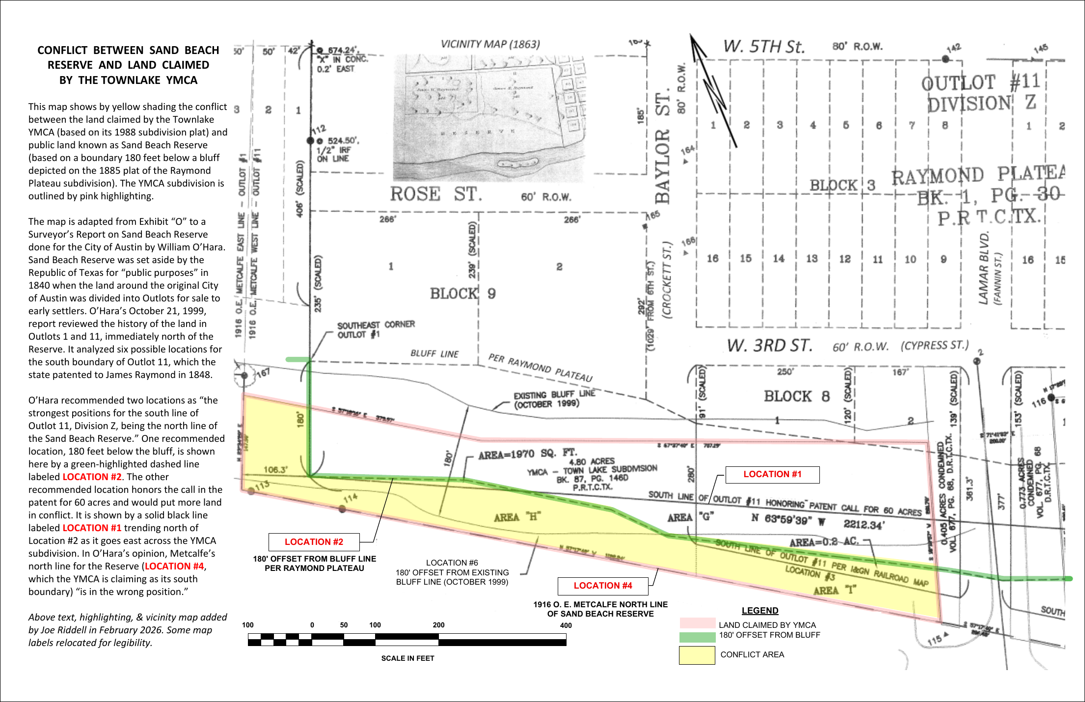
Researcher and attorney Joe Riddell argues that these facts place approximately 1.9 acres claimed by the YMCA inside the Reserve, triggering the reversion clause. His grid count puts the conflict area at about 40% of the 4.80-acre subdivision — a little under 2 acres; it is a manual map-based estimate, not a boundary survey. The archive presents the documents behind the argument so readers can evaluate it.
A compressed chronology
The present conflict begins with the founding of Austin, not with the current development proposal. Four events orient the documentary trail.
Congress of the Republic required 400 acres in the Government Tract to be reserved.
Metcalfe fixed the Reserve's north line theoretically, and later private claims relied upon it.
Austin conveyed about five acres west of Lamar to the Boy Scouts.
Surveyor William O'Hara recommended two boundary locations and rejected Metcalfe's line.
Why this is active now
The formal Planned Unit Development application filed July 24, 2026 for 1100 W. Cesar Chavez describes three residential towers with up to 750 market-rate condominiums, at least 90 affordable rental units, and a replacement YMCA with childcare. It requests a maximum PUD height of 435 feet and up to 93% impervious cover.
Those figures belong to the current proposal context, not to the historical proof. The formal application and the earlier Development Assessment are both available in the archive, together with a guide to the City staff comments issued on September 1, 2026.
What you can do
The fate of the PUD rezoning will be decided at public hearings by the City of Austin. Texas law gives the Land Commissioner and the Attorney General standing to go to court to enforce the public-purpose restriction the State placed on Reserve land in 1945 (Natural Resources Code §31.068). Leave your email and we'll tell you when there's a moment to speak up.
Form not loading? Email info@sandbeachreserve.com and we'll add you.