Reading guide
Start here, in plain language.
A short set of questions and answers to orient you before you open the documents. Where an answer states a settled fact from the record, it is presented plainly. Where it states an interpretation, it is labeled as attributed analysis — a conclusion argued by Joe Riddell, not a court ruling.
What is Sand Beach Reserve?
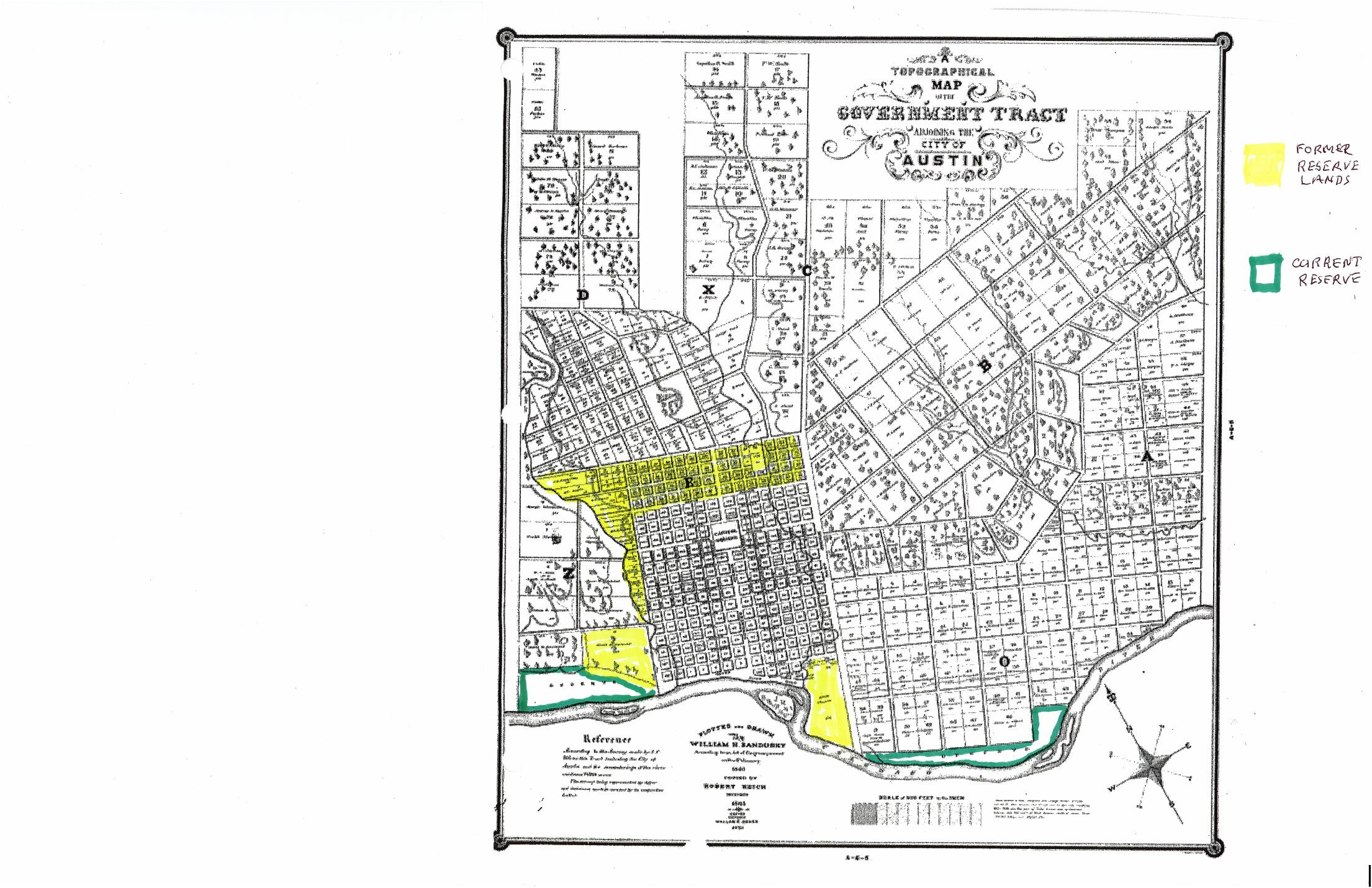
Land along the north bank of the Colorado River (Lady Bird Lake) in Austin. In 1840 the Congress of the Republic of Texas directed that 400 acres of the Government Tract be set aside “for such public purposes as Congress may hereafter direct.” After part was split off and sold in 1850, the Reserve remained in two tracts: an east tract and a west tract of roughly 85 acres, extending from the Austin High School area toward West Avenue. This website focuses on the west tract. In 1945 the State sold the Reserve to the City of Austin — but only for public purposes, and with a condition that any part the City later sold would revert to the State. See the 1840 timeline entry and the 1945 grant.
What land is actually in dispute?
Approximately 1.9 acres at the TownLake YMCA site, 1100 W. Cesar Chavez Street. Joe Riddell's grid count puts the conflict area at about 40% of the 4.80-acre subdivision — a little under 2 acres. This is a manual map-based estimate, not a boundary survey. On the conflict map it is the yellow area — where the YMCA's claim overlaps land that Riddell's analysis places within the Reserve. The boundary page explains the competing boundary lines.
Where is the boundary supposed to be?
The 1848 patent for Outlot 11 described its south line as running 60 yards — 180 feet — below the bluff of the river. O'Hara's 1999 report treats the 1885 Raymond Plateau plat as the best evidence of where that bluff ran. Measuring 180 feet south of it gives the boundary that surveyor William O'Hara labeled Location #2 in his 1999 report to the City. Read the 1848 entry, 1885 plat, and O'Hara report.
So how did public land end up inside a private subdivision?
Through what Riddell identifies as a survey error compounded by a sale. In 1916 O. E. Metcalfe surveyed the Reserve on the ground but drew its north line as a theoretical line scaled from a map, rather than locating that boundary in the field; surveyor William O'Hara later concluded that line sits too far south. On Riddell's analysis, the railroad's 1961 sale of a five-acre tract below the bluff to the City brought Reserve land into the chain: according to O'Hara's 1999 survey, part of that tract lay more than 180 feet below the bluff, and so inside the Reserve. The City's 1963 sale of the tract to the Boy Scouts then carried that Reserve land into private title. The YMCA bought it in 1967 and platted it in 1988. The record is in the 1916 survey and Metcalfe’s report, the 1961 railroad deed, the 1963 resolution and deed, the 1967 deed, and the 1988 plat. Attributed analysis Riddell argues the Reserve portion reverted to the State in 1963 and never became private property, so it cannot lawfully be developed as part of the subdivision.
What does “reversion to the State” mean here?
The 1945 grant from the State to the City said: “in the event of sale by the City of Austin, of the property herein granted, all parts thereof so sold shall revert to the State.” On this reading, the moment the City sold Reserve land (in the 1963 conveyance), title to that portion returned automatically to Texas. Attributed analysis Whether a given strip was inside the Reserve depends on where the boundary truly lies — which is the whole point of the map.
Is this just one person's opinion?
No. Riddell and registered professional land surveyor Ansel Gary Glover had raised the boundary problem before 1999. William O'Hara — a former Director of Surveying and Chief Surveyor at the Texas General Land Office — then analyzed six possible boundary lines for the City, recommended two, and explicitly wrote that Metcalfe's 1916 line “is in the wrong position.” Glover's earlier reports explored competing boundary locations; O'Hara's later report made the direct finding about Metcalfe. Attributed analysis Joe Riddell builds on O'Hara's report to argue the reversion consequence. Readers can check the Glover material, O'Hara report, and other source documents themselves.
What is being proposed for the site now?
Current context The formal PUD application filed July 24, 2026 describes three residential towers containing up to 750 market-rate condominiums, a minimum of 90 affordable rental units in a separate building, and a replacement 110,000 SF YMCA with childcare. The requested PUD standards allow a maximum height of 435 feet and up to 93% impervious cover. Those are requested development limits, not a statement that every tower would reach 435 feet. These figures supersede some numbers in the earlier 2025 Development Assessment and may change as review continues. See the current proposal page, open the filing, or read the guide to the City staff comments on it.
Is this website against the YMCA?
No. The archive is about a question of land ownership and public-purpose restrictions, and it keeps that separate from any view of the YMCA as an institution or of housing on the site. Factual history lives on the record pages; opinions about what should happen are labeled and kept on the current proposal page. Responsibility for the content is taken personally by the author — see About the archive.
Who decides what happens next?
The redevelopment runs through the City of Austin's zoning and PUD process, with review by bodies such as the Environmental Commission, Planning Commission, and City Council. Attributed analysis Because state land and a public-purpose restriction are involved, Riddell anticipates the General Land Office and Attorney General may also have a role; a 1997 statute (Natural Resources Code §31.068) gives them standing to enforce such restrictions. The City’s own reviewers have already commented on the application — see the guide to the September 2026 staff comments.
How do I read the underlying documents?
Start with the history timeline: most entries link to the deed, plat, survey, ordinance or report behind it. The Documents page lists every item in date order, from the 1839 surveys to the current City filings, and its filter box finds any of them by year, type or keyword.
Most of the archive is primary record — patents, deeds, plats, surveys, Council resolutions, court papers and the City's own filings. Items that are interpretation rather than record, such as Joe Riddell's research and this site's guides, carry an Analysis label: they are a reading of the record, not the record itself.
Two pages help with the hardest material. The boundary shows how the competing survey lines relate. The guide to the City staff comments summarizes the 24-page Master Review Report and cites every point to the comment it comes from.
A guide is a starting point, not the evidence.
Nothing here is legal advice or an official determination of title or boundary. Read it alongside the primary documents and reach your own view.