Background primer
How the Reserve came to be — and where it stands.
A short orientation to Sand Beach Reserve: its creation in 1840, what has happened to it over the years, and its status today. For the full sequence of events, see the chronology; for the sources, see the documents.
1839–1840
A capital, and land set aside for the public.
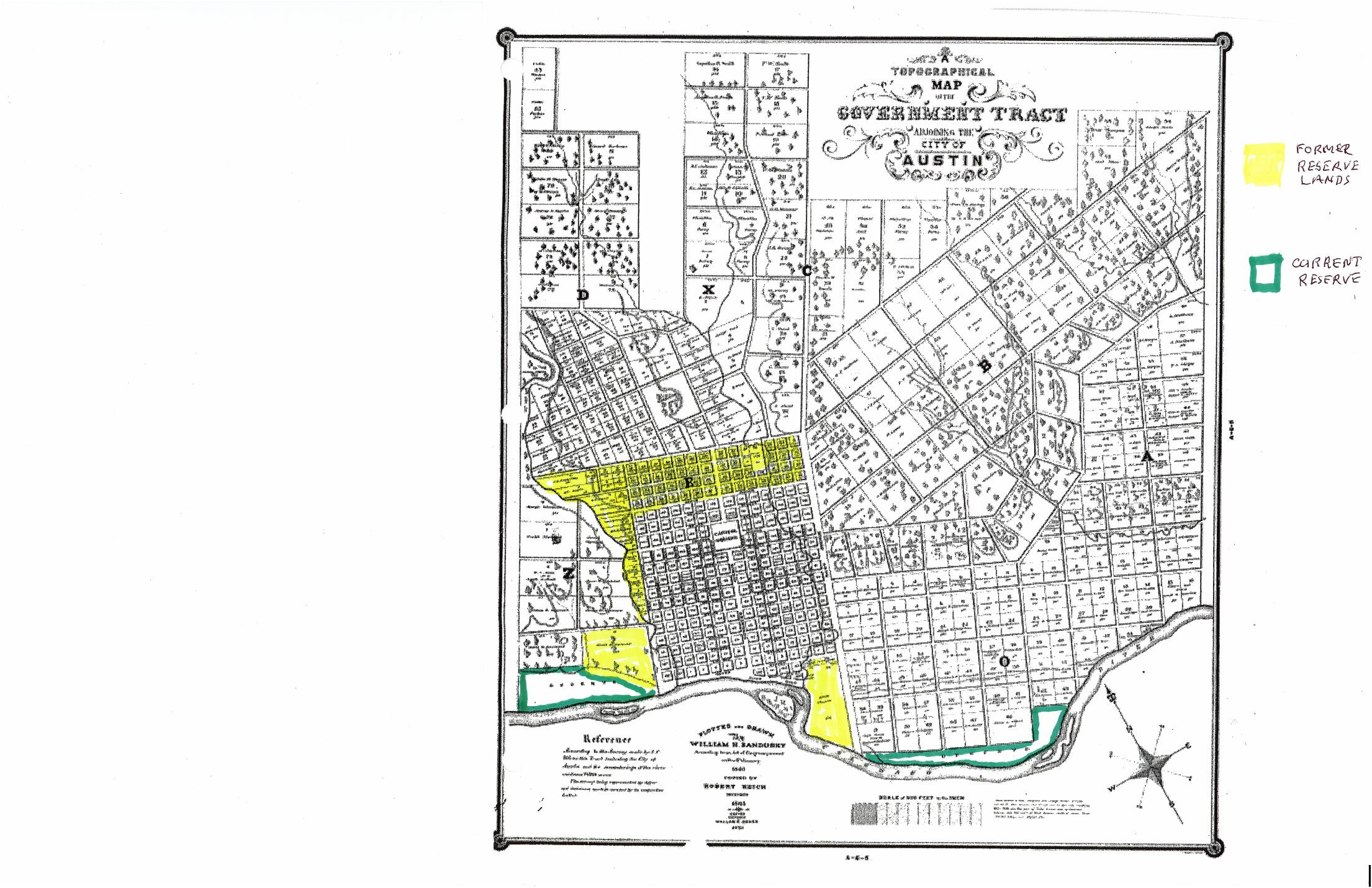
When the Republic of Texas chose Austin as its seat of government in 1839, officials assembled a "Government Tract" of more than 7,000 acres. A 640-acre townsite was surveyed into blocks and lots and sold at auction. In 1840 Congress directed that the rest be divided into larger "Outlots" — and, critically, that 400 acres be reserved "for such public purposes as Congress may hereafter direct."
After part of that reserved land was split off and sold in 1850, Joe Riddell's annotated map identifies the remainder as two tracts along the north bank of the Colorado River: the East and West Sand Beach Reserve. The western tract — about 85 acres between the Austin High School area on the west and West Avenue on the east — is the subject of this website.
The boundary question
A line measured from the bluff.
In the vicinity of North Lamar, the Reserve's northern edge was tied to the river bluff. When Texas patented the adjoining Outlot 11 to James Raymond in 1848, the patent placed its south line 60 yards — 180 feet — below the bluff. Everything below that line remained public Reserve. The 1885 plat of the Raymond Plateau subdivision, drawn at one inch to 100 feet, shows the bluff, and O'Hara's 1999 report treats it as the best surviving evidence of where that line falls.
In 1916, surveyor O. E. Metcalfe surveyed the Reserve on the ground, but fixed its north line by scaling from a copy of an earlier map rather than locating that boundary in the field. Attributed analysis Surveyor William O'Hara later concluded that Metcalfe placed the Reserve's north line too far south; on Riddell's reading, that discrepancy is the root of the modern conflict — explained on the boundary page.
1945 to today
Public purposes, and a condition that still binds.
In 1945 the State sold the Reserve to the City of Austin — but only for public purposes, and with a condition that any part the City later sold would revert to the State. Over the following decades much of the City's waterfront land, including Reserve land, was dedicated as parkland (1985). Litigation over the Reserve east of Lamar in the 1980s–90s produced court rulings on the "public purposes" restriction and, in 1997, a state law giving the Land Commissioner and Attorney General standing to enforce such restrictions.
Attributed analysis On the west side of Lamar, where the YMCA site sits, Joe Riddell contends that the Reserve is subject to fewer complications than the area east of Lamar — and that a portion now claimed by the YMCA reverted to the State in 1963 and remains public land today.
This is a draft primer.
This orientation remains subject to his final review. Read it alongside the primary documents and the source-linked chronology.